![]()
|
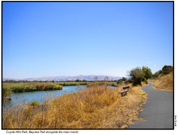
Coyote Hills Regional Park
(EBRP) Fremont
This park has many miles of accessible trails and fine birdwatching. If you have a fast power chair it's entirely feasible to take a bus on Padre Paseo Blvd to Patterson Ranch Rd and follow Tuibun Trail 0.6 mile to the entrance. Once in the park, the marshes on your right are criss-crossed by accessible trails, though they may be muddy in the rainy season, while the mostly paved Bayview Trail offers about a 3.5 mile hike around the eponymous hills, with only a few medium steep stretches. Some other trails in these hills are also useable; notably the Apay Way Trail, mostly well graded fine gravel, which goes 1.5 more miles south. |
|
Very shortly after passing the Quarry you reach the overpass, which crosses Hwy 84 above the Dumbarton Bridge toll plaza and continues down to the Don Edwards SF Bay Wildlife Refuge. (If it is the quarry that interests you, you could get there much more easily by coming north from the Wildlife Refuge -- the only obstacle is a modest climb to the overpass.) |
|
Details: The picnic area and the Visitor Center are pleasant, as is the Dairy Glen group campground, which has recently been improved with the addition of accessible (vault) toilets.Unfortunately the ones inside the Visitor Center still have wheelchair stalls too small to permit closing the door behind your chair. At least there's a portable toilet outside for those who are willing to forego running water to get privacy. AC Transit line 238 stops at Padre Paseo and Patterson Ranch Rd. By car, exit Hwy 84 at Paseo Padre Parkway, go north a couple of miles to Patterson Ranch Rd, left to the park.. There is an admission charge when the kiosk is attended. Dogs other than service animals are not permitted in some parts of the park. There are blue spaces and accessible toilets at both parking areas; benches are provided along the marsh trails, at the junction of Alameda Creek and Bayview Trails and at the west end of Alameda Creek Trail, but are less frequent on the hillier trails. Last visit September 2012. |